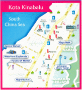
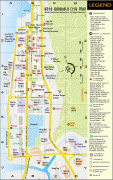
Kota Kinabalu (Kota Kinabalu)
 |
 |
In the 15th century, the area of Kota Kinabalu was under the influence of Bruneian Empire. In the 19th century, the British North Borneo Company (BNBC) first set up a settlement near the Gaya Island. However, it was destroyed by fire in 1897 by a local leader named Mat Salleh. In July 1899, the place located opposite to the Gaya Island was identified as a suitable place for settlements. Development in the area was started soon after that; and the place was named "Api-api" before it was renamed after Sir Charles Jessel, the vice-chairman of BNBC, as "Jesselton". Jesselton became a major trading port in the area, and was connected to the North Borneo Railway. Jesselton was largely destroyed during World War II. The Japanese occupation of Jesselton provoked several local uprisings notably the Jesselton Revolt but they were eventually defeated by the Japanese. After the war, BNBC was unable to finance the high cost of reconstructions and the place was ceded to the British Crown Colony. The British Crown declared Jesselton as the new capital of North Borneo in 1946 and started to rebuild the town. After the formation of Malaysia, North Borneo was renamed as Sabah. In 1967, Jesselton was renamed as Kota Kinabalu, Kota being the Malay word for City and Kinabalu after the nearby Mount Kinabalu. Kota Kinabalu was granted city status in 2000.
Kota Kinabalu is often known as KK both in Malaysia and internationally. It is a major tourist destination and a gateway for travellers visiting Sabah and Borneo. Kinabalu Park is located about 90 kilometres from the city and there are many other tourist attractions in and around the city. Kota Kinabalu is also one of the major industrial and commercial centres of East Malaysia. These two factors combine to make Kota Kinabalu one of the fastest-growing cities in Malaysia.
Kota Kinabalu is named after Mount Kinabalu, which is situated about 50 kilometres east-northeast of the city. Kinabalu is derived from the name Aki Nabalu meaning the "revered place of the dead." Aki means "ancestors" or "grandfather", and Nabalu is a name for the mountain in the Dusun language. There is also a source claiming that the term originated from Ki Nabalu, Ki meaning "have" or "exist", and Nabalu meaning "spirit of the dead".
The word kota comes from Malay word kota which in turn comes from the Sanskrit word कोट्ट (kota) which means fort, fortress, castle, fortified house, fortification, works, city, town, or place encircled by walls. It is also used formally in a few other Malaysian towns and cities, for example, Kota Bharu, Kota Tinggi, and Kota Kemuning. It can also be used informally to refer to any towns or cities. Hence, a direct translation of the name Kota Kinabalu into English would be "City of Kinabalu" or "Kinabalu City".
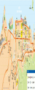
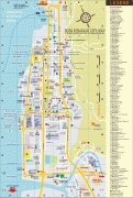
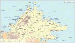
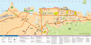
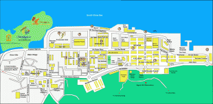
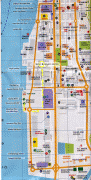
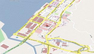
Map - Kota Kinabalu (Kota Kinabalu)
Map


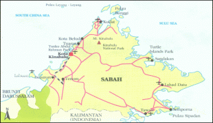


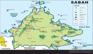
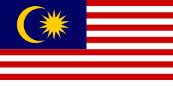
Country - Malaysia
 |
 |
| Flag of Malaysia | |
Malaysia has its origins in the Malay kingdoms, which, from the 18th century on, became subject to the British Empire, along with the British Straits Settlements protectorate. Peninsular Malaysia was unified as the Malayan Union in 1946. Malaya was restructured as the Federation of Malaya in 1948 and achieved independence on 31 August 1957. The independent Malaya united with the then British crown colonies of North Borneo, Sarawak, and Singapore on 16 September 1963 to become Malaysia. In August 1965, Singapore was expelled from the federation and became a separate independent country.
Currency / Language
| ISO | Currency | Symbol | Significant figures |
|---|---|---|---|
| MYR | Malaysian ringgit | RM | 2 |
| ISO | Language |
|---|---|
| ZH | Chinese language |
| EN | English language |
| MS | Malay language |
| ML | Malayalam language |
| PA | Panjabi language |
| TA | Tamil language |
| TE | Telugu language |
| TH | Thai language |